

THE PLATE TECTONICS
THEORY THE DEBATE STILL OPEN

THE PLATE TECTONICS THEORY: THE DEBATE STILL OPEN - PAGE 2
Let's look at the Atlantic and the west coast of Africa with the Google Earth Global Gravity Anomaly Map. Note the zones of oceanic fractures extending indistinctly towards the interior of Africa. The black dashes highlight areas of oceanic fractures that extend into the interior of Africa.


These plots appear subjective at first glance, but the detailed geological records of the African continent confirm the existence of these lineaments. The oceanographer Xavier Le Pichon was disturbed by the sight of such an alignment between the famous Romanche fracture and the Precambrian lineaments of Africa. If Le Pichon had devoted a little time to the collection of other indices of this kind, he would soon notice the weaknesses of the PTT. Undertaking such an avenue goes against the craze of the theory in vogue at the risk of being isolated in a marginal minority. Sometimes a scientist decides not to dwell on something that contradicts his theory. I often did it with my own theoretical models. But when contradictory data accumulates we must revise our paradigms and live with the doubt. Since the beginnings of modern oceanography, data contradicting PTT has been accumulating and still we are unwilling to revise our paradigms. Until recently, ocean drilling was struggling to break through sediment to reach basalt. With the recent launch of the Chikyu project, we will be able to settle the issue.
Under the Amazon basin there is a deep rift that collapsed during the Precambrian era. This mega geological structure is expressed with a series of lineaments that extend with the fracture zone in the Atlantic Ocean.


The southern end of the African continent is equally intriguing. The black dash indicates an oceanic fracture zone that extends into the eastern coastal zone of the continent which is in harmony with old Precambrian structures.


In 1994, my colleague and I submitted a publication for an international geology conference. We proposed a study between the lineaments of the African continent, the fracture zones of the Atlantic and those of the Indian Ocean. We included the following illustration: In orange we see the Archean provinces (the oldest of the Precambrian era).
In orange we see the Archean provinces (the oldest of the Precambrian era). One of the two editors rejected the conference-publication openly admitting his position in favor of the PTT. For him, these alignments had to be just coincidences. After our reply, the second editor was forced to apologize admitting the bias of the other editor.
Several peer review journals are exclusively protagonists of the PTT. They form a decades old establishment that resists against the idea of a continuity between oceanic fracture zones and continental structures. In the face of such opposition, a researcher will have to content himself with publishing in a government or university press or in a journal such as IBTA or NCGT Journal. Once, an editor of a major tectonic journal told me how he was filtering articles to avoid any trouble with some influential scientists. Several science journals have this attitude, it is well known. I admit that a little of orthodoxy in science does not hurt. Do you make a discovery that upsets the traditional paradigms? We are entitled to ask you for a more insightful argumentation. Keep in mind that some Nobel Prize discoveries were first rejected by prestigious scientific journals for being unorthodox innovative.
I am still smiling when I look at this map of Neev and Hall (2000) published in the Geological Survey of Israel Current Research. The authors make a detailed analysis of a model they call slice tectonics.

Drawing on a wealth of literature on major continental Precambrian lineaments, the authors highlight extensions with oceanic fracture zones. What makes me smile is their use of acrobatic rhetoric to avoid any affront to the classic PTT.
I will not blame them. You must put water in your wine. In 2004, my colleague and I (Friedrich and Leduc) published a study of the curvilinear aspect of fracture zones of all oceans. We had discovered that these broad lines curved in precise directions according to their position north or south of the equator. We named this phenomenon hemispherical effect. Our two publishers acknowledged that this discovery was important.

We did not reveal to our publishers that our inspiration came from 3 sources: Neev and Hall (2000), several publications in IBTA and NCGT, and some of our thoughts diametrically opposed to the PTT. Also, we avoid mentioning that FZs extend into the continent as Precambrian lineaments. Also, at the request of one of the editors, we had to omit any comment on the PTT problems. In the following figure we see the bottom of the Atlantic with its Fracture zones. The red dashed line highlights an obvious crossing between two fracture zones.

According to the PTT these fracture zones should not intersect. In our article we did not insist on this aberration. The red dashed line was added only for this web page. This crossing occurred precisely at the equator according to the rule of the so call hemispheric effect.
We all have seen the first complete map of ocean floors published by the National Geographic Society (Heeze and Tharp, 1977).

On the map the parallelism between oceanic fracture zones is remarkably aesthetic. The illustration fits well with the initial model of ocean floor spreading according to the PTT. Already in the 1950s several oceanographers knew that oceanic fractures formed a complex assemblage of curved lines, punctuated by interruptions, intercrossing with extension with chains of seamounts. Some oceanographers have even emphasized the bias of this map. In the decades that followed, bathymetric oceanography made considerable progress, especially with the arrival of a project like Seasat.
The accuracy of the Seasat records highlights the orthogonal crossing between two large systems of large Pacific fractures (red and yellow dashed lines).


These crossovers are not visible on the Heezen and Tharp map of 1977 because the two fracture systems are interrupted in the West just before their intersection. According to the oceanographer Christian Smooth this omission was intentionally done. Indeed, already in 1974 (Smooth, 1993, 1994) the surveys were precise enough to highlight the crossover of these fractures. To add to this irony, the National Geographic Society republished the “implemented” 1990 map BUT still omitting these elements so fatal for the PTT.

I prose two books by Christian Smooth, geologist oceanographer, which expose the inconsistencies of the PTT. His books are more relevant for discovering a historical context in which oceanography was often biased in favor of the PTT.
![51ZikJ2ryYL._SX338_BO1,204,203,200_[1].j](https://static.wixstatic.com/media/65462a_c8cf8f37ac994ac1b9f2dadb2bf1626c~mv2.jpg/v1/crop/x_0,y_0,w_340,h_498/fill/w_59,h_87,al_c,q_80,usm_0.66_1.00_0.01,blur_2,enc_auto/51ZikJ2ryYL__SX338_BO1%2C204%2C203%2C200_%5B1%5D_j.jpg)
![81h86DioR7L[1].jpg](https://static.wixstatic.com/media/65462a_1f57f6c09109441c9e42e93e665fd169~mv2_d_1700_2200_s_2.jpg/v1/crop/x_98,y_0,w_1503,h_2200/fill/w_60,h_87,al_c,q_80,usm_0.66_1.00_0.01,blur_2,enc_auto/81h86DioR7L%5B1%5D.jpg)
These monographs summarize dozens of articles that the author has published over 2 decades. The most staggering thing is that none of his articles have received a single reply. Yet, Smooth has always published in peer review journals. How did we come to ignore such data?
I would like to remind our readers that in the history of geology, no theory has given so many “explanations” to the many geological elements of our planet. Some geologists remember that the PTT of the 70s had caused a craze so disproportionate that the research budgets were reorienting in favour of this theory. Many ambitious researchers became too opportunistic to dare to publish the aberrations of the theory.
I always remember this student who was finishing his PhD on PTT in a prestigious geophysics department. We were on an excursion in the Belgian Ardennes. In the evening at the meal I shared with him several publications contradicting the PTT. He fell out of his chair because he had never been exposed to these articles. He realized how he was kept in ignorance.
Another time I was talking with a geophysicist well known for his models on the convection movements in the mantle. I shared with him some Pacific ocean data contradicting PTT. He remained so incredulous that he refused to check the suggested references.He made the comment that there will always be those antagonists who take pleasure at disturbing the established scientific truth. These articles were all based on reports from international teams such as Deep Sea Drilling Project.
The problem seems to be social or epistemological. Let's continue before becoming too philosophical ...
THE STRANGE BASEMENT OF THE CONTINENTS
The study of the deformation of the ancient continent basement is named basement tectonics. For 3 decades, research groups in this discipline have tried to break through the mysterious processes at the base of our continents (See, IBTA Publications 1974-2004). This science has highlighted compromising correlations for PTT.

The United States gravimetric survey (Hildenbrand et al., 1982) highlights the Precambrian structure of the bedrock. The map reveals long curving lineaments (Barosh, 1987) ) crossing the entire continent.

Below, we have juxtaposed the previous map with that of the bottom of the Atlantic (Warnken, 2001). Yellow lines: The oceanic fracture zones that seem to extend with the old Precambrian lineaments of the continental crust.

These fault lines limit long strips of the continental crust that were laterally offset from each other. The most intriguing aspect are these lines extending with the fracture zones of the Atlantic Ocean. Is this a coincidence? These long strips are very old structures while the ocean is supposed to be younger (Jurassic to Tertiary). More than a billion years apart should separate the ages of the two crusts. Another strange aspect is the constant 'rejuvenation' of the foundations of all continents across all ages. Moreover, many geologists had recognized that the North American basins were subsiding according to these basement structures. We will not deal here with this mystery of geology.
Kinsland (1983) even proposed a major fault break along one of the most important lineaments of the USA. By observing the images of this movement in the sideshow below, we can clearly see the juxtapositions of the ancient structures of the Precambrian basement. Both parts of the continental slices were sheared in the Precambrian period. With a zoom in... Precambrian structures seem to agree.


This structure seems to be prolonged with oceanic fractures. Some geologists have extrapolated the lines of these lineaments to the globe. As an example, we previously cited the work of Neev and Hall (2000) about their so-called slice tectonics theory. The lines of the oceanic fracture zones seem to be continuing with those of the continental lineaments. These alignments are in complete contradiction with the PTT, at least with the conventional view of the theory.
CONTINENTAL GRANITE IN THE OCEAN BOTTOM
Ocean drilling beyond continental margins need big budget. Unfortunately, these boreholes rarely cross the whole thickness of sediments accumulated on the ocean floor. Occasionally a borehole reaches the basement composed of basalt lava. The gabbro is unreachable. We know its existence indirectly. To read more see Wikipedia on oceanic lithosphere.
Since drilling is expensive, the bottom dredging technique is commonly used. Luckily, the heavy shovel that scrapes the bottom can bring back pieces that come from the depths of the oceanic crust. Volcanic eruptions and some moderate tectonic forces occasionally bring back these precious samples normally inaccessible by drilling. The walls of oceanic fractures are often valued when sampling is possible.
To the great surprise of the oceanographers, the dredging of the Atlantic Ocean Ridge has sample a surprising amount of Precambrian and Paleozoic continental rock. On the map below, we see a sector that covers an area of over 800,000 km2. It is estimated that there are thousands of outcrops.

Some might suggest that Ice ages icebergs floated their continental moraine cargo before dropping them over the site. Our modern ships occasionally unload their ballast in the mid of the ocean. We hardly believe in these 2 explanations.
Many geologists still believe that Iceland's geology complies well to the predictions of PTT. Strangely, volcanic eruptions have brought from deep down to the surface fragments of continental minerals.
I was inspired by several publications including Dickins et al (1992) to compile a map of oceanic sites that gave indices of continental crust.

GONDWANA PROMOTION
Everyone will recognize this famous map of Gondwana so ubiquitous in our textbooks.
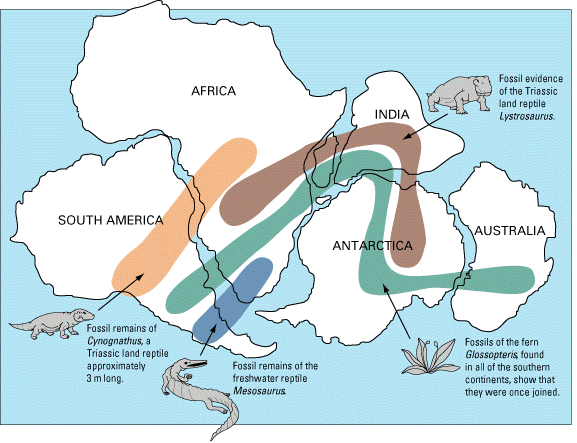
But few of us are aware that the original was taken from the work of Edwin H. Colbert’s Wandering Lands and Animals published in 1973.

The caption of the picture states "Gondwanand reassembled, and some of the paleontological links that bind it together".
Curiously, the image was only a promotional schema which anticipates future discoveries waiting on the field. Should we forgive Colbert for this advertising artistic license? He is one of the paleontologists who Triassic fossils in Antarctica. In the color version, we can see the long, distinct color regions (by product of the fossils sorting) which suggest how nicely the pieces of the puzzle fit together. Here is the reality of our current knowledge:

We do not see the aesthetics of Colbert’s map. You can generate this map yourself at https://paleobiodb.org/navigator/.
Choose Triassic era at the bottom; enter the fossils Lystrosaurus, Glossopteris, Cynognathus and Mesosaurus and then you are.
Thanks to the microeos.wordpress website for the above info.
Since the work of South Africans, Alexandre du Toit (1927, 1937), we know that the flora and fauna of the Triassic circulated between the three continents. Those who opposed the continental drift proposed that these Triassic fossils were spread across on ancient bridges (in yellow) later submerged under the ocean.

The aim is not to propose one theory against another but to realize that demagogy can easily infiltrate our geological pedagogy. Other sciences such as physics and chemistry are constantly challenged by technological applications. Each institute can repeat the same experiences and flush out frauds or demagoguery. In geology, theories are historical and therefore many events are unobservable in real time. There is no time travelling.
REFERENCES :
Barosh, P.J., 1987, Neotectonic Framework of the United States, in Basement Tectonics 7: Proceedings of the Seventh International Conference on Basement Tectonics, held in Kingston, Ontario, Canada, August 1987, Page 277.
Bullard, E, Everett, J E and Smith, A G, 1965. ‘The fit of the continents around the Atlantic’, published in the Philosophical Transactions of the Royal Society of London, Series A. Vol. 258, No. 1088, pp 41-5.
Dickins J.M., Choi D.R. & Yeates A.N., 1992 ‘Past distribution of oceans and continents’, in: New Concepts in Global Tectonics, Chatterjee & Hotton, 1992, pp. 193-199 (p. 198).
du Toit, A.L. and Reed, F.R.C. , 1927, A Geological Comparison of South America with South Africa, Carnegie Institution of Washington, Washington, USA
du Toit, A.L., 1937, Our Wandering Continents; An Hypothesis of Continental Drifting, Oliver & Boyd, London, UK
Garrett, W.E. (ed.), 1990. Atlantic Ocean Floor. National Geographic, 177, 61 a. Generalized Bathymetry on World Chart, North Atlantic Area
Google Earth Global Gravity Anomaly
-
Source of ocean data:
-
Sandwell, D. T., R. D. Müller, W. H. F. Smith, E. Garcia, R. Francis, 2014, New global marine gravity model from CryoSat-2 and Jason-1 reveals buried tectonic structure, Science, Vol. 346, no. 6205, pp. 65-67, doi: 10.1126/science.1258213, 2014.
-
-
Source of land data:
-
EGM2008 Gravity Anomalies and DOV Data - Nikolaos K. Pavlis, Simon A. Holmes, Steve C. Kenyon, John K. Factor; Journal of Geophysical Research: Solid Earth (1978-2012) Volume 117, Issue B4, April 2012
-
Friedrich, J. and Leduc, G., 2004, Curvilinear patterns of oceanic fracture zones; Journal of Geodynamics 37(2):169-179, March 2004
Hildenbrand, T.G., R.W. Simpson , R.H. Godsen and M.F. Kane, 1982,
‘Digital colored residual and regional Bouguer gravity maps of the conterminous United States with cut-off wavelengths of 250 km and 1000 km’ U.S. Geol. Survey Geophysical Investigation Map, Map GP-0953-A
James, K.H., 2010. Observations on New Magnetic Map from The Commission For The Geological Map Of The World. New Concepts in Global Tectonics Newsletter, no. 57.
Kinsland, G.L., 1983, Transcontinental Transform Fault Across North America, Basement Tectonics 5: Proceedings of the Fifth International Conference on Basement Tectonics, held Cairo, Egypt in 1983, p.267.
Korhonen, J.V. et al., 2007. Carte des Anomalies Magnétiques du Monde. Commission for the Geological Map of the World. Paris
Neev, D., Hall, J.K., 2000. Whole mantle convection as the cause of the spiraling global system of lithospheric geosutures. GSI Current Research 12, 168–176.
Smith, W.H.F., Sandwell, D. T., 1997, Measured and Estimated Sea Floor Topography (map version 4.2), World Data Center-A for Marine Geology and Geophysics research publication RP-1.
SMOOT, N.C., 1993. Bathymetry: Collection, Processing, and Interpretation: NAVOCEANO Train. Man. TM 01-93, 299.
SMOOT, N.C., 1994. Plate-wide Pacific trends-orthogonal fracture intersections, EOS, Trans., AGU, 75(25), 69.
Thomas, W.A., 1977, Evolution of Appalachian- Ouachita salients and recesses from reentrants and promontories in the continental margin: American Journal of Science, v. 277, p. 1233.
Warnken, R., 2001, Global Relief Images, 2-Minute Gridded Elevation Data, NOAA/National Geophysical Data Center, Boulder, Colorado, Download at http://www.ngdc.noaa.gov/mgg/image/2minrelief.html.